Showing posts with label Urban Planning. Show all posts

Monday, February 25, 2013

NYC twitter map of languages

This GIS/social media relationship rocks my socks off. Researchers at Fast.co recently turned 8.5 million tweets into an interactive map of languages in NYC. As they explain:
You can walk the streets of New York City and hear a veritable babel of languages. It’s estimated that as many as 800 languages are spoken around the city. A new mapping project takes a look at which ones are the most spoken on social media.
Five percent of tweets were in languages other than English, with Spanish, Chinese, Russian, Korean, Italian, and French Creole topping the list. These are not the same top languages spoken by New Yorkers, respectively, which raises the interesting question of why not? Are some NYC language groups less inclined to use Twitter? Can the discrepancy be explained by exogenous factors like poverty or internet access? Or does everyone just tweet in English?


Sunday, February 17, 2013

CA's Experiment with Redevelopment Agencies

California Governor Jerry Brown began deliberations with the Legislature over dissolving the state’s 400 redevelopment agencies in the winter of 2011, and by June of that year they finalized the legislation. The abrupt demise of California’s massive multi-billion dollar local planning instrument has left many cities with administrative gaps in their economic development initiatives, and nearly $2 billion remain in limbo while local governments struggle to keep funds in their jurisdiction. 

Sacramento contests that local redevelopment agencies were choking off much-needed revenue for state services with little benefit to the state at large, while local governments defended them as powerful tools for revitalizing urban centers and propagating ‘smart urbanism’. The move has pitted competing interests of public agencies against each other in a debate over who is best suited to take on their planning responsibilities.


What is a Redevelopment Project Area?


A redevelopment area is a special development district similar to enterprise zones, incremental tax finance districts, cultural districts and others, with several significant characteristics that set them apart. California redevelopment areas were designated by local municipal governments – typically a city or town, but sometimes counties as well – and they allowed the local government to capture a greater share of property taxes while reducing the private cost burden of new developments.


Thursday, January 24, 2013

DC Metro expansion, or "Tunnels, tunnels, tunnels"

The Washington Post published a graphic this morning that outlines the current proposals for long-term development of the DC Metro system. The $26 billion proposed plan to upgrade the Metro includes several key ideas to relieve crowding on the subway by 2040.

Of course nearer-term changes to the District's rail network are still in the works. Washingtonian's can get stoked as Summer approaches and the first phase of the Silver Line nears completion. Set to open mid-2013, Phase 1 will connect Reston, VA to the rest of civilization. (That would have been useful a few months ago when Chelsea was considering a job out there....). The last 11.5 miles of Phase 2 servicing the airport and Loudoun County is expected to wrap up in 2018, assuming that WMATA can reach an agreement for financing the rest of the project anytime in the next 3-4 years. The Silver Line is the largest expansion project by route mileage since the inception of the Washington Metro in 1976.

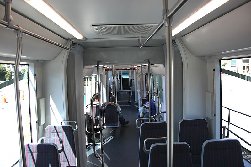
Interior of a DC streetcar constructed
in 2008, still unused.
The District Department of Transportation (DDOT) is also finalizing plans to complete the H Street/Benning Road line of the long-anticipated streetcar network, expected to start revenue-service this summer. Of course, this project has been riddled with local infighting and other delays (including a lawsuit from the original Czech firm constructing the streetcars, which have sat rusting in a railyard in NE forst several years), and so a 2013 opening may be more a matter of cosmic luck than deliberate planning.

Wednesday, June 13, 2012

District Bikeways, or "The obstacle course"

It looks like DC is finally looking to make moves on District bikeways just in time for the transit bill to take away local control of bike-ped funds. Yay timing!

Let me drop you some knowledge about biking in DC. It's not great. The District has received a lot of attention recently for its increasingly bike-friendly policies coming down the proverbial pipes, but the experience includes plenty of indirect routs, unprotected bike lanes, disjointed bikeways and drivers that are largely uneducated on right-of-ways and, on average, very bad at driving.


Tuesday, May 29, 2012

Mapping locals and tourists by photo tags

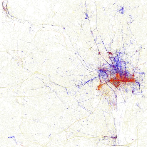
I have been following San Francisco's own "digital cartographer" Eric Fischer for awhile now, so I'm a bit surprised that I just found this set on his Flickr photostream. In 2010 Fischer presented a series of maps that documented the intensity of geo-tagged photography in over a hundred metro regions around the world. In his updated set he breaks this information down a bit further, into 'tourists' and 'locals' - users/photographers that uploaded multiple photos of the area more than a months apart.

The project was initially an effort to see if the earlier Geotaggers' World Atlas maps were primarily sourced by tourist photography, but the product became a veritable GIS map comparing trending tourist activity to areas where local residents spend their time.

Locals and Tourists #7 (GTWA #8): Washington, DC
Washington, District of Columbia

Tuesday, May 22, 2012

District Parks Divided, or "Occupy protesters vs. land use planning"

Is your local park locally or federally owned? I'm willing to bet that most of you have never really considered this question. For most people around the country there is no reason to (except for in places like the Presidio in SF, which is still a national park with apartments and storefronts in it). But jurisdiction over DC's parks is split between the federal government - specifically the National Park Service who manages them and the Architect of the Capital that plans and designs them - and DC local government. This has two important implications. The first is an issue of finance; since Washington government does not own the land or the structures on the property, it does not see any revenue generated from vendors/tourism and it cannot leverage them as collateral assets in financial planning (i.e. bonds, loans, credit ratings, etc). It might sound crazy to leverage a park or recreation area on a public loan, but it's actually pretty common and most local governments have many other tools for managing repayment issues so that they don't actually give up the property in a pinch.

But the second is a bit more interesting from a public interest perspective. This disparity was recently exemplified during the Occupy DC protest when - after several months of sit/lie ins in McPherson Square and other parks - District residents overwhelmingly supported the removal of long-term encampments. Despite Washington's overwhelmingly left-leaning political culture and recognition that Occupy had made its point, residents wanted use of their parks back. But there was one simple problem: DC government did not have jurisdiction over the parks.

Tuesday, April 10, 2012

New concepts designs for the Mall, or "@__@"


The Trust for the National Mall released on Tuesday concept drawings of a dozen finalists in a competition to redesign the National Mall in Washington, DC.

Since last September, architects and designers have been competing for the chance to make over areas near the Capitol, Washington Monument and Constitution Gardens, which was once imagined as a pastoral park near the Lincoln Memorial. Each of the areas under consideration were selected in order to enhance their utility as public spaces, and refurbish features that have decayed over years of use. Each of the designs would bring major changes, adding amenities including food options and restrooms.

While the proposals have been largely welcomed in feedback in social media, there have also been voices of concern that the new designs might undermine the district's historical features. But to be fair, the current theater is pretty lame compared to most of the new concepts. I mean, the new one would come with fireworks and thousands of engaged audience members > >
Some renovation would probably be good for the District's less than premium public spaces.


Check out the rest of the ideas at the Trust for the National Mall's REACT webpage.


Friday, March 16, 2012

What Kind of Country, or "This American Life Presents..."

With the downturn of the global economy in 2007-2008, Americans were quickly faced with fiscal austerity decisions in their local and state governments. With less money on their books, cities like Trenton, NJ and Colorado Springs and, yes, even old homesteads like San Francisco and San Jose were forced to acknowledge  new realities that they could no longer afford the same kinds of services and benefits that were once routine. While cities, counties and states - and eventually even the federal government - grappled with technical tweaks to revenue streams and budgets cuts, residents began to confront expectations about what their governments could and should be doing. By the time we were fighting about healthcare reform in the US, it was apparent that these issues were digging at something deeper - questions like what is government, and what is the public community that we live in? Who belongs in it? What do we want from it? What does it want from us? We all began arguing about political philosophy (though not always well).

In a recent episode "What Kind of Country", Public Radio International's "This American Life" explored what these question mean to us through three stories from the across the US of how reforms have, and sometimes haven't, taken residents where they hoped.


Tuesday, March 13, 2012

District Government, or "Whaaaaaat?"

Every year the municipal government of the District of Columbia develops a draft budget and annual financial plan with the data that it receives from its agencies and departments, like all other local governments. Officials hold public hearings for review and input, finagle public opinion and internal politics, and eventually agree on a final working budget. The local council would then approve the budget plan, but when it comes to the District, the US Constitution says that the federal legislature gets a fair chance to ruin everything first.

Sunday, February 26, 2012

By The Books, or "Welcome to the District (Part 2)"

Let's start this introduction with a basic profile before we get into the gritty stuff.

Hey look the Census made a profile graphic for just the occasion!
The District of Columbia is home to approximately 618,000 residents as of July 2011. Of that number, 50.7% are Black or African American, 38.5% are White. 9.1% are Hispanic or Latino (among all races) and 3.5% are Asian. The total population of the District grew by about 2.7% between the 2010 Census and the July 2011 survey. The federal District itself is only 68 square miles, including about 7 square miles of waterways.

One of the most interesting demographic features of Washington is the age distribution of its residents. Nationally, 24% of American residents are below the age of 18 years; but in the District of Columbia this rate drops to 16%. That means there aren't a lot of kids or teenagers around. Nonetheless the median age of Washington is 34 years, the lowest of any US state.

"So... DC is full of mid-thirty year olds," you might suppose. Cool, a young city! In reality though, the city is even "younger" than that. Who likes population pyramids?!

Saturday, February 25, 2012

Welcome to the District, or "First time in a long time"

I've had some trouble conceptualizing how this blog could be useful now that I’ve moved from the ranks of San Francisco public employees to a mere graduate student in America's most politically obsessed and emotionally avoidant city. However, I recently realized that all of the oddity and nonsensical happenings of this town that made it difficult to write about coherently are perfect fodder. Many things about this place are counter intuitive, and neither you nor I probably understand what's happening out here these days, so let's see what we figure out together.

Thursday, May 5, 2011

Muni "bonds", or "How I rode my bike and then caved in"

As a not-wealthy resident of San Francisco, I have a relationship with MUNI transit. It's not great, it's not (usually) terrible, but it is certainly special. The most accurate comparison would be to the relationship you might have with that college friend or roommate that always hangs around and conveniently has a car, but no one is quite sure why he's part of the group because the only time you talk about him is to talk shit or recall a ridiculous story that usually ends with someone dancing drunk on a table at a stranger's house or getting slapped in the face at a Wendy's. But still, you keep coming back for more - and part of you kind of wants to.

On Tuesday I missed the 31-Balboa inbound and chose to walk down to the 5-Fulton, as is often the case. MUNI open sourced it's vehicle tracking data and I have a nifty app that tells me when the buses come now, but to no surprise it has an incredibly difficult time keeping track of the 31 inbound. "6 minutes" it says, and then a moment later it refreshes and reads "10 minutes". Once I relax and settle into the last sips of my cofee, it tells me "12 seconds, ha ha. you're screwed I tricked you." So now my only reliable signal is the mid-pitch ZZZ-ing noise of the electric engine of a bus tearing its way down Balboa toward my apartment, past my apartment, and away from my apartment. When the winding noise first penetrates my windows in the morning, I have approximately 50 seconds to grab my gear, get down the stairs and run two blocks to the bus stop. It may or may not actually stop.

Whatever is going on here, just leave the station and walk away.
So on Tuesday I walked to the 5, boarded, and headed in to the urban core for work. The bus filled up, became full, continued to fill up until there was nowhere to move, and then a middle aged man vomited everywhere in the middle of his second bottle of gin.

On Wednesday I opted to ride my bike to work, and it was wonderful, and clean, and warm. I rode past the Conservatory of Flowers, along dirt trails, amongst giggling children playing in fields with remarkably absent parents, and I even lost a 2 1/2 mile street race through the Panhandle and down Page by several seconds with a strange hipster on another Peugeot. All this and I still got to work 20 minutes earlier. But of course, I can never stay away forever. I always come back with some rationalization, secretly curious about strangers I’d see and the next MUNI mishap that I could be part of. And in the back of my mind, I always think that it will be a little bit more convenient than another mode of transportation. After a 300 ft climb uphill on my first mile going home, dodging cars on narrow streets and bikes flying in the opposite direction, I had my justification.

For now I will split my time between the open, beautiful bikeways of Golden Gate Park and the congested anarchy of MUNI in rush hour, until the next health-hazard drives me to the streets once again. No matter the malfunctions, delays, anxiety, reckless abandonment of traffic code, claustrophobia, and generic icky-ness of certain bus lines, it seems I will always return to this awkward friend.


One writer on Muni Diaries sums up his the experience nicely, with graphics!

Wednesday, May 4, 2011

So....who gets the money?


I wrote an entry this past March reflecting the political controversy around redevelopment agencies in California. Governor Brown still argues that the State ought to dissolve the agencies to reclaim short-term costs to Sacramento's tax revenue, but others argue that redevelopment agencies foster long term growth and profits in areas that would otherwise not develop in the normal market.

There are examples of abuse and success for either side of the argument to hold up to the spotlight, but the San Francisco Redevelopment Agency is noted as one of the most successful cases in the program. The agency has integrated into the City's administrative framework since its incorporation in 1948 by taking on responsibilities in financing, planning and coordination in a variety of City projects, and even asserted its management capacity in increasingly complex initiatives. The SFRA now holds jurisdiction (often shared) over more than 10% of the territory of San Francisco. Active project areas include:

» Yerba Buena Center
» Hunters Point Shipyard
» Rincon Point/South Beach
» Bayview Hunters Point
» Bayview Industrial Triangle
» South of Market
» Mission Bay North & South
» Transbay
» Vistacion Valley


» *Treasure Island redevelopment is no longer part of SFRA, and is instead managed by the quasi-independent Treasure Island Development Authority (TIDA)


The Agency is an entity legally separate from CCSF, but it only performs certain functions authorized by the City and County of San Francisco and in areas designated as Redevelopment Zones by the Board of Supervisors.

With the threat of dissolution looming awkwardly in the air over every redevelopment conversation in San Francisco, CCSF is left with the uncomfortable task of figuring what to do with the billions of dollars in projects, contracts and funds - and 10% of San Francisco - that will have to be handed to someone else to manage. Realistically, the RA projects already underway will likely continue without intervention or suspension, but the real problem is the coming disruption to administrative services and the juggle of authority that always gets more complicated than it needs to in SF. Now, there is also a whole bunch of money, land and social justice conflict involved to upset even the most idealistic department.

Tuesday, May 3, 2011

Furious cabbies

Over one hundred taxis encircled San Francisco City Hall today in a long chain through the Civic Center. I made my way back to the office through cabbies wailing on their horns and protesters angrily displaying obscure signs. They blocked intersections, bus lines and pedestrians from passing, damning the whole area to gridlock while locals and tourists grew evermore upset.

But why? I had just walked through the park square only 30 minutes ago and it was warm and tranquil. The masses on the steps of City Hall now seemed to be wielding unrelated banners, including bright yellow signs for "Ross Mirkarimi for Sheriff", "Miller 4 San Francisco Mayor", "Unions bite back", the generic "Si se puede" posters in various colors, the more obscure " نعم نستطيع " and dozens of 8.5x11 papers with illegible black and white block text covering the entire sheet. Whatever the initial catalyst, the arrival of Sal Castaneda and his posse of reporters appeared to draw people out of the woodwork with something to say to the cameras. 

But the taxis, why so many taxis?! Since San Francisco has maybe a dozen to begin with, the looping mass of yellow, white and green cabs seemed improbable. No one could explain what the fuss was about, until one woman in the security line at City Hall said simply "MTA. It's MTA, and me. They're basically here for me." She walked away toward the elevators, leaving behind her a cloud of ominous-ness.

I later learned  that the Cabs were protesting a Board of Supervisors meeting, in which the BoS was debating the new MTA regulations that would waive a rule prohibiting cab companies to recover the 5% surcharge per credit card payment from drivers, thus transferring the cost. A 5% fee may not sound like much on its face, but it comes with responsibilities to maintain digital screens and hardware - and on top of that, there are no taxis for hire in San Francisco today. So it is, de facto, a big deal.

For a Full story and explanation of the issue, this San Francisco Sentinel article gives a good summary.

Friday, April 22, 2011

The Bay could have looked like this...

In the 1960s, before the creation of BART or modern strategic transportation plans, the prospects for San Francisco looked very different than what we see today.

My fellow Fellow Eliot Chang recently forwarded me an image from his office that immediately grabbed my interest. He is part of San Francisco's Department of Public Works (DPW), and he uncovered a treasure trove of alternative proposals for bridges, tunnels, freeways and subways that were ultimately abandoned to the City's archives, but not before their designs and specs were completed. See if you can imagine them now.

Here are some of my favorites.

Alternative bridges and tunnels for trans-bay travel, circa 1967.

Thursday, April 21, 2011

SFPark goes live with mobile app for parking

Download the iphone app
For those of you readers with iPhones in and around San Francisco, your day has finally come. SFPark released its mobile app for iPhone users today, less than a week ahead of the program's full-fledged launch. SFPark has already activated 5,000+ smart meters around the City, and users can now pay with credit and debit cards, as well as coins and SFMTA parking cards. Rates are adjusted several times daily for business and peak hours, and the rate structures will [only*] occasionally change at the start of new months. As for the "quality of life" issues, drivers will now be able to access graphical information on parking availability and pricing in each of the pilot neighborhoods. Small sensors keep up-to-the-minute record of used and free parking spaces - not only in garages, but also on the street.

See how it works, and revel in the glory of how much easier your life just got. Those of us with Droids or not-smart phones will secretly envy and resent you for now.